Saturday, December 21, 2013

Severe Weather just before Christmas


The Storm Prediction Center office is located in Norman, OK and their job is to watch out for severe weather and issue warnings in advance of a storm.  Public Safety workers, Emergency Management, Pilots and Storm Chasers watch the SPC website every day to keep track of important severe weather information.

The Storm Prediction Center has been very active in monitoring a severe weather event that will affect the Lower Mississippi and Tennessee Valleys. This event may affect a larger area as time progresses.  If you have family and friends that live in the Southeastern US you should contact them to see if they are aware of the possibility of a severe storm.  The storms that may be see in this area could product damaging winds, severe thunderstorms and possible tornadoes.  The following states have the greatest chance for Tornado Warnings to be issued:  AR, AL, KY, TN & MS.

Please watch the official briefing issued by the SPC below: 


SPC Website: http://www.spc.noaa.gov/

Sunday, December 8, 2013

Snowy Wasteland

Meteorologists work really hard.  They study to keep up to date using the latest developing technology to forecast the weather that affects everyone and everything from events, school, work and play.  Safety is the number one priority that pushes professional Meteorologist to work 24/7 in keeping the public safe.  In the last few days I have watch several sources track this latest storm in its formation and progress through parts of the US until it affect the Mid-Atlantic states.  Originally the forecasters with the aid of computer modes predicted a wintry mix of snow, ice and rain with possible snow accumulation of a trace to about and inch in part of SE PA.  When the storm arrived the forecasts quickly were updated to 1-3 inches of snow.  As the afternoon approached the forecast was again updated to 2-4 inches just north of Philadelphia and some areas south might end up receiving 8-10 inches before changing to freezing rain then to all rain Monday morning.

Courtesy of The National Weather Service Mt. Holly WFO

My drive -  I had to drive from Horsham to Allentown, PA.  The total time for the drive was approximately 4 hours round trip.  During my journey, I saw snow and ice throughout my drive and saw several accidents including two spin outs on roads which clearly needed more attention.  In fairness, the snowfall rate (probably about and inch an hour) made it difficult for Pendot to keep the roads salted and cleared.  For the most part they did a good job and I was able to drive without many issues (without having a 4X4)

Here is a short video of part my drive.  Temperature was around 27 degrees and you can see how the ice and snow started to affect the wipers.


Saturday, November 30, 2013

First Storm Chase

Storms are seen all over the world and most storms are just an everyday part of life bringing much needed precipitation and hopefully enough to avoid a drought.   I actually waited way too long to become a trained Storm Spotter and was interested in studying about storms for a long time. (Not sure why I hesitated and wished I pursued my interests with more focus.

I was with a photography group that I have been with and I had just recently bought a digital camera that could film simple non HD video.  I had no experience chasing or documenting storms and if you do want to do this I recommend that you seek real training or go with a person with experience because it can get dangerous.  PLEASE NOTE: I do not recommend that you go out and chase storms. When I was filming this video I was not anywhere near a shelter and I thought I was going to get struck by lightning.

In 2011 I took a Storm Spotter training and a year later I took the advanced class and now that I had learned about storms I now feel that what I did back in 2008 was foolish.  I did not have a NOAA Weather radio or mobile radar, which means that we were partially blind and we did not know that there were damaging winds that touched down not far from us.  Lessons learned looking at this in retrospect.
Slama Photography 8/2008


Below is a video that I filmed in segments and found this footage today (yes, years later)


When I got home I heard that there was storm damage less that a 1/2 mile from where I was located while filming and if I recall correctly residents thought their area was hit by a tornado.  I have tried several times searching for news reports and found that this was not a tornado but a severe thunderstorm with a strong isolated downdraft that generates winds that could be as strong as a EF1 Tornado.  This particular storm had different clouds that showed both horizontal, vertical rotation, and lots of lightning strikes.  This was filmed right after leaving Valley Forge Park where we witnessed torrential rain and a flash flood.
Reading more about that day, I found out that there was a hail storm in Chester County and another one in Elk Township NJ where Storm Spotters measured hail at 1 inch in diameter. (which is evidence of a severe storm)  The clouds you see in the video and the pictures below show vertical development which is another warning sign of a severe storm.  I could not find  if there was a tornado watch issued that day.

Here are a few pictures from that day.  You can see the clouds how the storm was moving by us, the clouds were swirling above us showing signs of vorticity.

Flash Flood at Valley Forge Park
Possible Scud cloud

I hope you enjoyed this story, the pictures and the video. Thanks for following The_Weather_Vane!

Tuesday, November 26, 2013

Cloud Streets


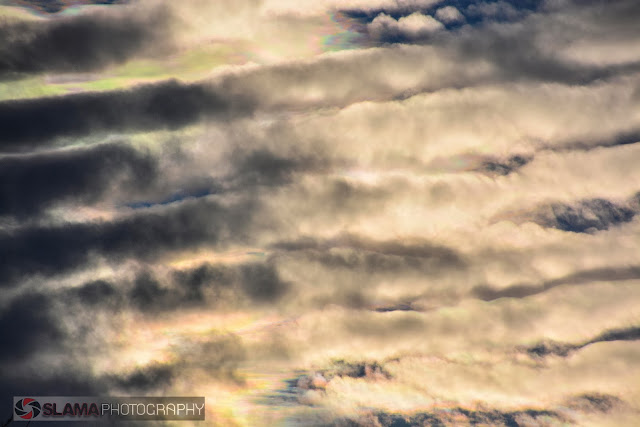
Watching the skies for some folks may not be the most entertaining thing in the world.  However for others who watch the skies for cloud formations and storms in general, well I have something to show you today.   I took a Meteorology 101 course and during the course we discussed basic formations of clouds and how they relate to current and future weather conditions.  Last Sunday while I was on a short hike with my brother and a friend we ran into a cloud formation that had us looking up for awhile.  I looked up this particular type of cloud and found that this is a rare event called "Horizontal Convective Rolls" aka Cloud Streets.  In short, this is generated by rolling motion caused by counter-rotating air that is parallel with the ground usually generated by instability from a strong arriving cold front.


In part I was unprepared.  I write for a blog and I was face to face with a tremendous natural science display and I did not have a camera with me.  Thankfully I was not alone and my co-photographers in a photography group I belong to helped out by taking pics that day.

Here is another pic of the rolling clouds.


 Watching the cold front roll in from the western sky had us mesmerized and that was not the end of that.  When we left the park (in separate cars) we all unknowingly and randomly stopped and took similar pictures of the sky during sunset.   That sky produced a wild display of light, texture and color.  Below you will see what I mean.   So the next time you hear about a cold front, plan to keep a camera with you and if you take a great picture, don't forget to share.


Sunday, November 17, 2013

Storms in November


Typically the month of November means Fall weather and families getting ready for Thanksgiving.  We don't normally associate November for a month for bad weather.  


I spent a good portion of today following national weather headlines (obviously more than a normal person would).   What caught my attention today is how unprepared the general public is about warning for severe weather.   I find it curious how sports fans in Chicago fill a stadium when there were ample tornado warnings going on at the time today.    Not very far from Chicago a strong tornado hit Washington IL.  The storm that produced this tornado was triggered by a large sweeping cold front moving east and it has been causing severe weather in a large area of the country.   (it is not over yet). 

I have not been studying the weather for much time and I have said before that I am not a pro (a Meteorologist) but I have watched the local news almost on a daily basis.  I can understand why the 6 o'clock news could put off some viewers due to negative stories about curruption, images of war and natural desasters that are of far away places.  I guess I am part of a select few who follow news and study about the weather that sets me apart from the general public.   This is why I am a volunteer and why I became a Storm Spotter.   I have been through a really bad flood and I was totally uniformed of the weather event that hit the area I was located at the time.   I did not want to see people caught off guard like I was (I could have drowned or had a bad car accident).

  • Social media is one possible way to inform the public.  

I have spoken to a few experts that are not really fans of using social media to communicate with the public for emergencies. However most people do not want to buy a NOAA radio because they are either complicated to program or most folks simply do not want a alarm going off when a strong thunderstorm is upon us.
 I have written a few times before about FEMA, NOAA and The American Red Cross and their efforts to notify the public.  They even set up warning systems to trigger alerts in smartphones, however i recently heard that many people complained of false alarms and most people deactivated the alerts.    Apparently we have a no win situation except that I can try to post low key warnings on social medial well in advance of the storm.  I know that I do  not many followers however, if more people would do the same, we could have a better chance of reaching more people that are connected online.

If anyone has suggestions to improve communication to the public, (I am all ears)   Please tell me..

Cell phones are great, however they have limited battery time during a power outages and high winds can knock down cellphone towers.  I will not let this keep me plugging away posting weather info.

The National Weather Service issues a briefing when there is a possible severe weather event.
I hate to cry wolf and it seems sometimes that I may have hyped up a few storms however my intent is to help people be ready and not drive into a storm where they could be risking life and limb.
The NWS briefing that was issued today (11/17/13) describles an event of rain and possible strong wind gusts.  When there is an event like this we might not see much, but then surprise we have a strong wind even that knocks a large tree on your house.

So isn't better to pay attention to the news and try to learn how weather warnings work?

A big Thank You to the Mt. Holly NWS office in NJ for their warnings.


Actual full NWS Briefing - click here