Thursday, June 14, 2012

Extreme Weather - Dallas TX Hail Storm

This is being reported as one of the worst Hail Storms seen in Dallas Texas which occurred today.
Automobile windows and skylights in buildings have sustained severe damage from hailstones measuring from golf ball to baseball size hail.


Just as a comparison, here is what the diameter of  hailstones could be in a storm;

Hail Stone Diameter (in Inches)

Pea size  1/4 "

Penny  3/4 "

Nickel   7/8"

Quarter     1"  (Considered Severe)

Half Dollar    1 1/4"

Walnut or Ping Pong ball   1 1/2"

Golf Ball      1  3/4"

Hen Egg or Lime  2"

Tennis Ball    2 1/2"

Baseball        2 3/4"

Large Apple  3"

Grapefruit     4"

Softball       4  1/2"


Tuesday, June 12, 2012

Storm Watch and Storm Warnings


Our local office at The National Weather service in Mt. Holly New Jersey, has a team of meteorologists and other highly trained staff that watch for weather events 24 hours a day and make the decision to issue local weather watches and warnings to alert the general public of severe weather.

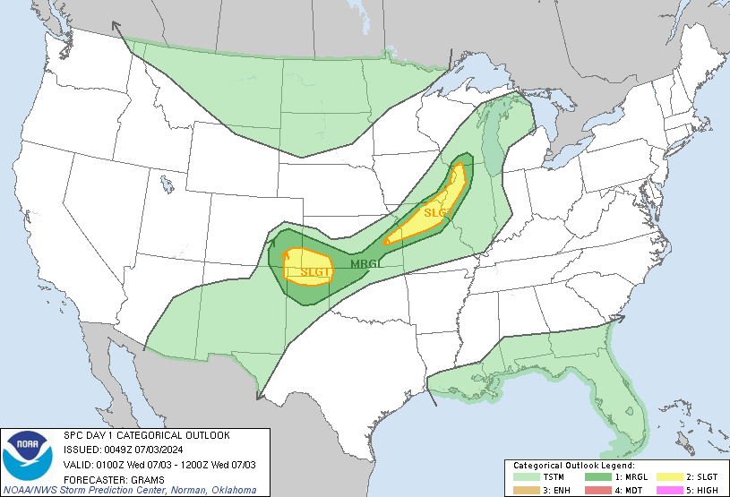
The Storm Prediction Center is part if the National Weather Service and is responsible to watch for events throughout the United States.   As an example, here is a map of today's national outlook for weather events.


The map can show snow, ice, thunderstorm, tornado and other types of watches and warnings.

  • What is a Watch?
A watch is used when the risk of a hazardous weather or hydrologic event has increased significantly, but its occurrence, location, and/or timing is still uncertain. It is intended to provide enough lead time so that those who need to set their plans in motion can do so.

  • What is a Warning?
 A warning is issued when a hazardous weather or hydrologic event is occurring, is imminent, or has a very high probability of occurring. A warning is used for conditions posing a threat to life or property.

These alerts are broadcasted via radio, TV and the internet, however the most reliable method  is through the NOAA Public Alert Weather Radio system.   These radios are sold to the public and and they alert you of severe weather.


Thanks to our National Weather service for watching over us!

For more information, please visit the source;  http://www.nws.noaa.gov/view/nationalwarnings.php?map=on

Friday, June 8, 2012

El Niño Watch Status

The Climate Prediction Center issued its report yesterday stating that "There is a 50% chance that El Niño conditions will develop during the second half of 2012."  Since La Niña ended in April we are now seeing neutral conditions.

NOAA's National Weather Service and their funded institutions, study both the effects of trade winds and ocean temperatures to see how these oscillations affect the state of our climate.


Where and how does El Niño affect us?

In the Tropics, El Niño episodes are associated with increased rainfall across the east-central and eastern Pacific and with drier than normal conditions over northern Australia, Indonesia and the Philippines. Elsewhere, wetter than normal conditions tend to be observed 1) during December-February (DJF) along coastal Ecuador, northwestern Peru, southern Brazil, central Argentina, and equatorial eastern Africa, and 2) during June-August (JJA) in the intermountain regions of the United States and over central Chile. Drier than normal conditions generally observed over northern South America, Central America and southern Africa during DJF, and over eastern Australia during JJA. El Niño episodes also contribute to large-scale temperature departures throughout the world, with most of the affected regions experiencing abnormally warm conditions during December-February. Some of the most prominent temperature departures include: 1) warmer than normal conditions during December-February across southeastern Asia, southeastern Africa, Japan, southern Alaska and western/central Canada, southeastern Brazil and southeastern Australia; 2) warmer than normal conditions during June-August along the west coast of South America and across southeastern Brazil; and 3) cooler than normal conditions during December-February along the Gulf coast of the United States.


To see the the ocean temperature change over time, visit here;  http://climatedriver.blogspot.com/p/sea-surface-temps-el-nino-status.html

As I explained before I have been caught in a tropical storm when I lived in Ecuador in 1998, where I saw intense flooding rains.   Here is a video that gives a good visual explanation of  El Niño.


Thursday, June 7, 2012

NASA's unmanned "Severe Storm Sentinels"


Human pilots have the disadvantage of "being human", it is obvious that the basic necessity of sleep would be both a safety issue and the fact that decreased flight time slows down the progress of much needed scientific data for the study of Hurricanes and severe storms.  Imagine an unmanned plane that can fly 28 hours non stop at an altitude of up to 60,000 feet. This in reality is Nasa's Global Hawk (HS3), which is a  mission that will begin this summer and continue for the next several years.
Image by NASA
What is the HS3 and what will it do ?   "Hurricane intensity can be very hard to predict because of an insufficient understanding of how clouds and wind patterns within a storm interact with the storm’s environment. HS3 seeks to improve our understanding of these processes by taking advantage of the surveillance capabilities of the Global Hawk along with measurements from a suite of advanced instruments," said Scott Braun, HS3 mission principal investigator and research meteorologist at NASA's Goddard Space Flight Center in Greenbelt, Md.


Here is an outline of HS3 instruments;

  • High-resolution Interferometer Sounder (S-HIS)
  • Advanced Vertical Atmospheric Profiling System (AVAPS) also known as dropsondes
  • Cloud Physics Lidar (CPL)
  • Tropospheric Wind Lidar Technology Experiment (TWiLiTE) (to be added in 2013)
  • High-Altitude Imaging Wind and Rain Airborne Profiler (HIWRAP)
  • Hurricane Imaging Radiometer (HIRAD)
  • High-Altitude Monolithic Microwave Integrated Circuit Sounding Radiometer (HAMSR)

NASA's Science Mission Directorate Global Hawk aircraft will deploy to Wallops Flight Facility from their home base at NASA's Dryden Flight Research Center on Edwards Air Force Base, California.

For more details, please visit NASA online at;  http://www.nasa.gov/mission_pages/hurricanes/missions/hs3/news/hs3.html


Sunday, June 3, 2012

Storm Clouds In Montgomery County PA

Today we had a series of thunderstorms moving through Southeast PA, pictures were taken by a fellow Storm Spotter and myself and we wanted to share them.

More storms appear to be moving from west to east, during the evening.

Horsham PA - 6/3/12
Storm Spotter photo by DES
The last pic (above) I believe was taken near the Upper Dublin / Horsham border in PA